|
|
Home
|
|
|
Geography is the study of the surface of the earth, including places, landforms, climate, and cultures. This page discusses the physical geography of Ventura County, California.
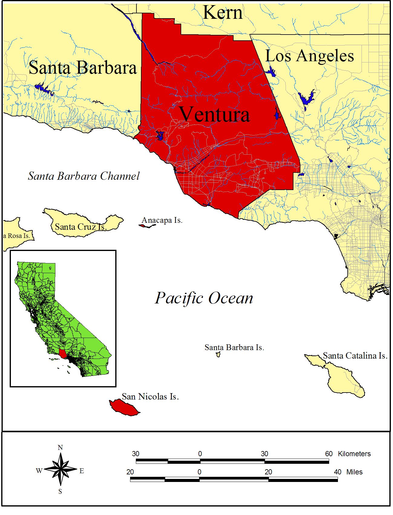
Ventura County is located in southern California, USA, along the east edge of the Pacific Ocean. The coastal portion occurs along the south and southwestern quarter of the County. Ventura County is bounded by Santa Barbara County on the west, Kern County on the north, Los Angeles County on the east, and the Pacific Ocean generally on the south (Figure 1, General Location Map of Ventura County).
Figure 1. General Location Map of Ventura County
Ventura County extends north to 34.9014şN latitude at the northwest corner of the County. The county extends westward at Rincon Creek to 119.47991şW longitude, and eastward to 118.63233şW longitude at the west end of the San Fernando Valley just north of Chatsworth Reservoir. The mainland portion of the county reaches southward to 34.04567şN latitude between Solromar and Sequit Point, west of Malibu. When including Anacapa and San Nicolas Islands, the southernmost extent of the County occurs at 33.21şN latitude and the westernmost extent at 119.58şW longitude, on the south side and west sides of San Nicolas Island, respectively.
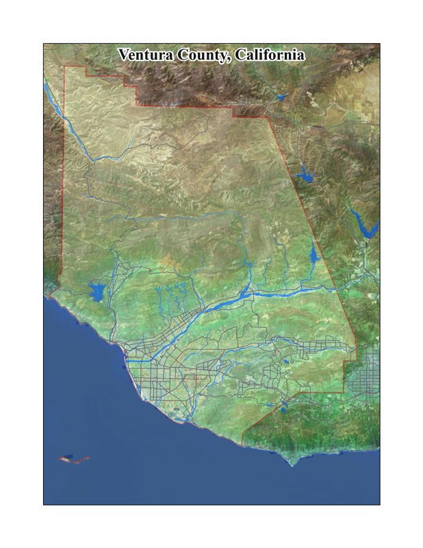
Ventura County occupies 480,996 hectares [ha] (1,188,562 acres [ac]) or 4,826 square kilometers [sq. km] (1,856 square miles [mi]), which includes Anacapa and San Nicolas Islands. The mainland portion of the county is 474,852 ha (1,173,380 ac), or 2,933 sq. km (1,833 sq. mi.) in area and ranges in elevation from sea level on the southwest to 2,692 meters [m] (8,831 feet [ft.]) above sea level at its northern border on Mount Pińos (Figure 2, High-altitude Aerial Map of Mainland Ventura County). There appears to be some discrepancy in the actual area covered by Ventura County, depending on the source. For example, according to the California County Fact Book, 1983 edition (California Supervisors Association of California 1983), Ventura County occupies an area of 482,668 ha (1,192,680 ac) or 2,999 sq. km (1,863.6 sq. mi), with 3,254 ha (8,040 ac) or 20.3 sq. km (12.6 sq. mi) of that as water. The discrepancy appears to be a little over 2,469 ha (6,100 ac), which does not correspond to the area occupied by the two islands within the County. The difference appears to match the area occupied by the section of the county in the northeast corner, where the Ventura County Board of Supervisors voted to give away approximately 6,100 acres to Kern County to accommodate a proposed development that Ventura County felt it could not provide adequate County services to. But why so much when much of that land is actually owned by the U.S. Forest Service?
Ventura County is approximately twice the size of the state of Rhode Island and a little less than the state of Connecticut. New Jersey is about twice the size of Ventura County.
Figure 2. High-altitude Aerial Map of Mainland Ventura County
Mainland Ventura County is located between 34ş00' and 35ş00'N latitude and 118ş38' and 119ş28'W longitude, excluding Anacapa and San Nicolas Islands, and is generally longer than wide. Anacapa Islands are the smallest and easternmost of the northern Channel Islands while San Nicolas Island is an outer southern Channel Island.
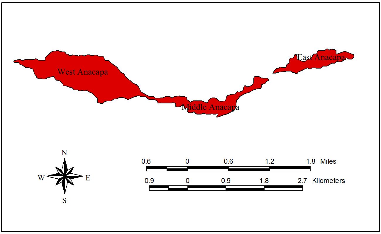
Anacapa Islands are approximately 247.3 ha (611 ac) in size, and comprised of three connected islands, referred to at West, Middle, and East Anacapa, measuring approximately 8 km (5 mi) from the west tip of West Anacapa to the east tip of East Anacapa at Arch Rock (Figure 3, Map of Anacapa Islands). West Anacapa is about 3.2 km (2 mi) long on its east-west axis and 1.2 km (0.74 mi) at it’s widest. Anacapa Islands are the easternmost and smallest of the northern Channel Islands, with Santa Cruz Island a few km westward (and part of Santa Barbara County). West Anacapa ranges in elevation from sea level to over 280 m (919 ft.) while Middle and East Anacapa range from sea level to 80 m and 60 m, respectively. Anacapa is centered (on its east-west axis) at about 34ş01' N latitude and 119ş25'W longitude. The lee side of the island is on the north, with the south side exposed to the prevailing westerly winds and the open ocean. Anacapa is owned by the National Park Service and is part of the Channel Islands National Park.
Figure 3. Map of Anacapa Islands
San Nicolas Island is approximately 6,167.6 ha (15,240 ac, 22 sq. mi) in size. It is approximately 15.52 km (9.7 mi) long on its northwest-southeast axis and 5.92 km (3.7 mi) wide at its widest point near the northwestern end. San Nicolas Island rises abruptly above the ocean and has a relatively flat top, like a mesa. It ranges in elevation from sea level to 276 m (907 ft.) and has approximately 37.8 km (23.6 mi) of coastline. The mesa averages 107 m (350 ft) on the North side, but is higher on the south, averaging 229 m (750 ft) in elevation. The center of San Nicolas Island is located approximately at 33ş15' N latitude and 119ş30'W longitude.
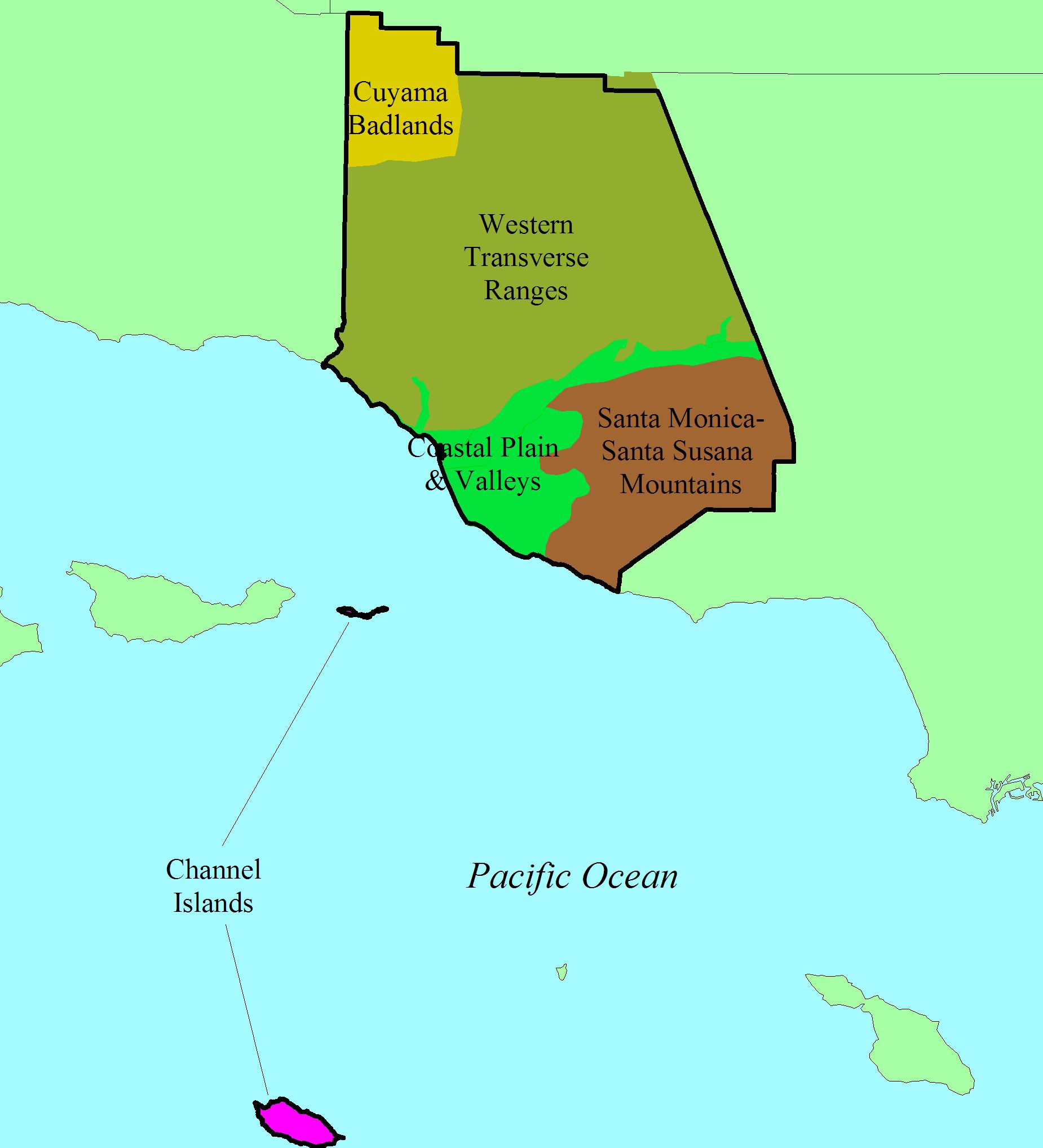
Ventura County has fifty-two geographic bioregions, as established by the author, aggregated into five major geographic features that corresponds more or less to physiographic regions:
- A broad coastal plain (the Oxnard Plain and Santa Clara River Valley, part of the South Coast and Western Transverse Ranges Subregions);
- The western portion of the Santa Monica Mountains, Santa Susana Mountains, and Simi Hills (part of the Western Transverse Ranges Subregion);
- The mountains and intervening valleys north of the Santa Clara River (northwestern portion of the Western Transverse Ranges Subregion);
- The Cuyama Badlands and eastern Sierra Madre Mountains (northwestern most part of the Western Transverse Ranges Subregion and southeastern most part of the South Coast Ranges Subregion); and
- The Channel Islands (Anacapa and San Nicolas Islands) (part of the Channel Islands Subregion).
Each of these major physiographic areas of Ventura County is described below and illustrated on Figure 4, Physiographic Regions of Ventura County.
Figure 4. Physiographic Regions of Ventura County
Coastal Plain and Valleys
The Coastal Plain and Valleys physiographic region of Ventura County is a broad, flat distributary delta that has been extensively modified by agricultural and urban development for over 200 years. The Coastal Plain and Valleys physiographic region includes the Oxnard Plain, lower Ventura River valley, Rincon coast,and Santa Clara River Valley. The soils of the Oxnard Plain are extremely deep and rich, providing some of the best farmland in the world, when irrigation is added. The Coastal Plain and Valleys is bounded by the Pacific Ocean on the west and south, the Santa Monica-Santa Susana Mountains on the east, and the Western Transverse Ranges on the north.
The Santa Clara River Valley extends for approximately 72 km (45 miles) from the mouth of the Santa Clara River to east of Castaic Junction in Los Angeles County and ranges in elevation from sea level to approximately 308 m (1,010 ft.), measured in the riverbed to Castaic Junction (in Los Angeles County). The valley trends east west, is the largest valley in Ventura County, and generally bisects the county north and south geographically. A few miles downstream from Santa Paula, the valley widens significantly and demarks the north perimeter of the Oxnard Plain, with the City of San Buenaventura (Ventura) on the north.
The valley narrows towards the east, especially near Santa Paula where the Oxnard Plain to the south gives way to South Mountain (the western end of the Santa Susana Mountains), which occurs on the south side of the valley. The lower elevations and flatter portions of the valley are fully developed for agriculture, with citrus predominating. The cities of San Buenaventura (Ventura), Oxnard, Santa Paula, Fillmore, and Piru occur along the banks of the Santa Clara River, from the Pacific Ocean inland, respectively. State Route 126 is the major transportation corridor of the Santa Clara River Valley.
Santa Monica-Santa Susana Mountains
The Santa Monica-Santa Susana Mountains trend east and west, with their western terminus at the eastern end of the Oxnard Plain. The mountains at the northwestern end of the Santa Monica Mountains are called the Conejo Mountains. The Santa Monica Mountains extend eastward towards Los Angeles, ending at the Los Angeles River in the Griffith Park area (in Los Angeles County) and are part of the Transverse Ranges and generally included within the Western Transverse Ranges subregion of the California Floristic Province. These mountains are rugged and have high relief, ranging from sea level along their southern edge to 948 m (3,111 ft.) on Sandstone Peak, immediately south of Boney Mountain, both located within Ventura County.
The Santa Susana Mountains also trend east-west, originating in the west at the northeast corner of the Oxnard Plain and extend eastward to the Newhall Pass in Los Angeles County. The Santa Clara River Valley creates the northern boundary of these mountains. The Simi, Little Simi, Las Posas, Conejo, and Santa Rosa Valleys occur between the Santa Susana and Santa Monica Mountains. The Santa Monica Mountains consist of Miocene volcanic and sedimentary rock formations. The volcanic formations, such as the Conejo Volcanics, offer unique edaphic conditions that support a large number of endemic plants, including several rare and endangered species. The Simi Hills and Santa Susana Mountains consist of Cretaceous and Miocene, and younger sedimentary rock formations.
Western Transverse Ranges
The Western Transverse Ranges are the dominant landform of Ventura County, occupying the northern two-thirds of the land area of the county. The Western Transverse Ranges are a collection of east-west trending mountain ranges with intervening valleys. As the name implies, the Transverse Ranges trend transversely to that of the other mountain ranges in California, which trend along north-south axes. The Western Transverse Ranges are extremely rugged and have high relief, ranging from sea level west of Ventura along the Rincon coast to 2,682 m (8,831 ft.) on Mount Pińos at the very northern edge of Ventura County. The primarily mountain ranges within Ventura County that make up the western Transverse Ranges, from south to north (and west to east) are:
- Rincon Mountain/Ventura Hills/Santa Paula Mountain;
- Santa Ynez Mountains/Nordhoff Ridge/Topatopa Mountains/Hopper Mountain/Whiteacre Peak;
- Ortega Hill/Dry Lakes Ridge;
- Pine Mountain Ridge/Sewart-Alamo Mountains/Cobblestone Peak;
- Mount Abel-Sawmill Mountain-Mount Pińos/Frazier Mountain; and
- Conejo/Santa Monica Mountains (here seperated out with the Santa Susana Mountains and Simi Hills as a distinct phyiographic region).
The San Emigdio Range occurs immediately north of Mount Pińos and Frazier Mountain, divided by the San Andreas Fault, which for the most part occurs in Kern County. Only the northeastern corner of Ventura County contains a small portion of the San Andreas Fault, placing all of Ventura County on the Pacific Plate. Intervening valleys, from south to north, include: Cańada Larga, Ojai Valley, Matilija Canyon, middle Sespe Creek (including Rose Valley), upper Sespe Creek, Cuyama Badlands (including Ozena Valley, Dry Canyon, Apache Canyon, Quatal Canyon, and smaller canyons), and Lockwood Valley. Cuddy Valley occupies the San Andreas Fault Zone immediately north of Mount Pińos and Frazier Mountain in Kern County.
Geologically, the Transverse Ranges are predominately of sedimentary formations, with a small amount of igneous and metamorphic rock in the northeastern corner of the county (Mount Abel-Mount Pińos, Frazier Mountain, San Rafael Peak, McDonald Peak-Sewart Mountain, Alamo Mountain). On the large scale, the Transverse Ranges include the Western Transverse Ranges, San Gabriel Mountains, San Bernardino Mountains, San Jacinto Mountains, and Santa Monica Mountains. Some geographers exclude Mount Abel-Sawmill Mountain-Mount Pińos from the Transverse Ranges and instead include them with the Sierra Madre Range. The Mount Pińos trilogy could also be considered the western terminus of the Tehachapi Mountains, or a part of the San Emigdio Range, which occurs immediately to the north on the other side of the San Andreas Fault. The San Andreas Fault separates the Pacific Plate from the North American Plate (so I guess they really aren't related to either the San Emigdio Range or the Tehachapi Mountains after all).
Cuyama Badlands
The Cuyama Badlands is a high desert region in northwestern Ventura County that receives only a little rainfall because of the rainshadow effect of the San Rafael/Sierra Madre Mountains to the west in Santa Barbara County. The topography is rugged and steep eroding cliffs on which few plants grow, hence the name "badlands". The nonmarine sedimentary strata are quite colorful, with the banding of the sedimentary rock layers providing strikingly stark and colorful natural displays, ranging from buff to red to blue and green.
The Cuyama Badlands are drained by the Cuyama River and its tributaries, which flows to the northwest into northern Santa Barbara County, then westward to the Pacific Ocean along the Santa Barbara/San Luis Obispo County line.
Channel Islands
Two of the eight California Channel Islands occur within Ventura County, Anacapa Islands and San Nicolas Island. Anacapa Islands are made up of three connected landmasses, which are referred to as West Anacapa (the tallest, largest, and most rugged of the three), Middle Anacapa (long and narrow with a generally flat mesa top), and East Anacapa (which is similar to Middle Anacapa). East Anacapa has a lighthouse and campground at its eastern end, near Arch Rock, a characteristic landmark. Anacapa Islands are the easternmost of a chain of islands forming the northern Channel Islands, and occurs east of the largest of the four islands, Santa Cruz Island. These islands are geologically similar, and related to, the Santa Monica Mountains, and are volcanic and sedimentary in nature.
San Nicolas Island is one of the four southern California Channel Islands, and is owned by the U.S. Navy, which means that access to the island is highly restricted. San Nicolas Island is mostly Eocene sedimentary rock and a cover of Quaternary deposits. The mountains and hills of the southern Channel Islands and their submarine ridges trend northwest, unlike the northern Channel Islands. San Nicolas Island is capped by a Quaternary marine terrace that has had sand blown up the northwest end of the island onto it. Mass wasting, fluvial erosion, wave erosion (coastal marine), and aeolian erosion and deposition are the main geomorphic processes.
|
|