
|
|
|
Ventura County Biogeography |
|
|
Home |
|
Biogeography is the study of the distribution of plants and wildlife on the surface of the earth. This page discusses the biogeography of Ventura County, California. Ventura County's geographic position on the coast of California lies at the focal point of six major unique geographic features: the Pacific Ocean, the Mojave Desert, the mountains to the south (San Gabriel Mountains connected indirectly to the Peninsular Ranges), the Sierra Nevada through the Tehachapi Mountains, the Great Valley, and the South Coast Ranges with influences from the north. The coastal parts of Ventura County have a moderating [marine] climatic influence that keeps temperatures mild yearround. The high mountains, reaching to subalpine elevations, provide sky islands that have floristic connections with the Sierra Nevada and holoarctic flora. The connections with the south and desert provide sources for subtropical (Madro-tertiary) floristic influences. The Mediterranian climate creates a rare climatic regime found only in four other parts of the world, which sets the stage for creating numerous habitat microhabitats, especially when combined with the varied and complex geology found in Ventura County. Ventura County has fifty-eight (58) geographic bioregions (biogeographic), as established by the author, which were created primarily for the sake of discussion, but have geographic integrity. These 58 bioregions all fall within the Southwestern Region of the California Floristic Province (the later extending from southern coastal Oregon to northern Baja California del Norte, Mexico). The bioregions are directly associated with a major landform, be it a mountain range, valley or canyon, or plain. Some are fairly small; however, they represent unique or important geographic places in the county that I wish to distinquish from other parts of the county. The Anacapa Islands are part of the Northern Channel Islands subregion of the California Floristic Province. Anacapa has been connected to Santa Cruz Island eons ago, but has never been connected to the mainland; however, the distance to the mainland was significantly less during the Pleistocene when sea level was much lower when much of the fresh water was in solid form as ice in the polar caps or glaciers. On the other hand, the landmass of Anacapa has been less, when sea level was relatively higher than it is today, as evidenced by the marine terraces clearly dominating Middle and East Anacapa Islands. San Nicolas Island is part of the Southern Channel Islands subregion of the California Floristic Province. It has always been isolated geographically. The 58 biogeographic areas of Ventura County are illustrated on Figure 1, Biogeographic Regions of Ventura County. Figure 1. Biogeographic Regions of Ventura County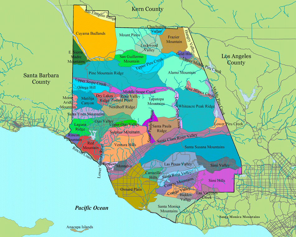
The 58 bioregions are listed below, starting in the northwest corner of the county, working eastward, then southward, with the islands listed last. Some bioregions have active links to floristic checklists available as PDF documents.
Western Transverse RangesThe Western Transverse Ranges are the dominant landform of Ventura County, occupying the northern two-thirds of the land area of the county. The Western Transverse Ranges are a collection of east-west trending mountain ranges with intervening valleys. The primarily mountain ranges within Ventura County that make up the western Transverse Ranges, from south to north (and west to east) are:
The higher elevations of the Western Transverse Ranges, generally above 5,000 feet, are vegetated by a mixed conifer forest dominated by Ponderosa Pine (Pinus ponderosa), Jeffrey Pine (Pinus jeffreyi), Sugar Pine (Pinus lambertiana), Black Oak (Quercus kelloggii), and montane chaparral shrub species. California White Fir (Abies lowiana) occurs at the highest elevations with patches of Incense-cedar (Calocedrus decurrens) on Pine Mountain Ridge, Alamo Mountain, and Mount Piños, but the Calocedrus seems to be lacking on Frazier Mountain for some reason. Disjunct relictual stands of Ponderosa Pine and Sugar Pine are found on Dry Lakes Ridge and Santa Paula Peak, respectively. On a sad note, the Ponderosa Pine colony on Dry Lakes Ridge appears to have been extirpated by the December 2018 Thomas Fire. Geologically, the Transverse Ranges are predominately of sedimentary formations, with a small amount of igneous and metamorphic rock in the northeastern corner of the county (Mount Abel-Mount Piños, Frazier Mountain, San Rafael Peak, McDonald Peak-Sewart Mountain, Alamo Mountain). On the large scale, the Transverse Ranges include the Western Transverse Ranges, San Gabriel Mountains, San Bernardino Mountains, San Jacinto Mountains, and Santa Monica Mountains. Some geographers exclude Mount Abel-Sawmill Mountain-Mount Piños from the Transverse Ranges and instead include them with the Sierra Madre Range. The Mount Piños trilogy could also be considered the western terminus of the Tehachapi Mountains, or a part of the San Emigdio Range, which occurs immediately to the north on the other side of the San Andreas Fault. The San Andreas Fault separates the Pacific Plate from the North American Plate (so I guess they really aren't related to either the San Emigdio Range or the Tehachapi Mountains after all). Cuyama BadlandsThe Cuyama Badlands is a high desert region in northwestern Ventura County that receives only a little rainfall because of the rainshadow effect of the San Rafael/Sierra Madre Mountains to the west in Santa Barbara County. The topography is rugged and steep eroding cliffs on which few plants grow, hence the name "badlands". The nonmarine sedimentary strata are quite colorful, with the banding of the sedimentary rock layers providing strikingly stark and colorful natural displays, ranging from buff to red to blue and green.The primary vegetation of the Cuyama Badlands is Pinyon-Juniper Woodland, dominated by Singleleaf Pinyon Pine (Pinus monophylla), California Juniper (Juniperus californica), and John Tucker Oak (Quercus john-tuckeri). Flatter areas contain Great Basin Sagebrush (Artemisia tridentata) and Rubber Rabbitbrush (Ericameria nauseosa subspecies). The Cuyama Badlands are drained by the Cuyama River and its tributaries, which flows to the northwest into northern Santa Barbara County, then westward to the Pacific Ocean along the Santa Barbara/San Luis Obispo County line. Coastal Plain and ValleysThe Coastal Plain and Valleys physiographic region of Ventura County includes the following biogeographic regions: Rincon Coast, Lower Ventura River, Pierpont Beach, Montalvo, Santa Clara River Valley, Oxnard Plain, and Camarillo Hills. The flora of these areas have been heavily insulted by agricultural, industrial, and urban developments. The soils of the Oxnard Plain are extremely deep and rich, providing some of the best farmland in the world, when irrigation is added. The plain is fringed along the coast by coastal dunes, back dune swales, and lagoons and estuaries containing coastal saltmarsh vegetation. Of course, most of the original coastal habitat has been lost to development, with only fragments remaining of what was once a diverse and rich environment. Coastal Sage Scrub and herbaceous plant communities, including coastal and riverine/palustrine wetlands once dominated these lowland areas. The coastal wetlands and dune systems, or remnants of them, in this physiographic region is at great risk from sea level rise, especially since the plants growing in these habitats have nowhere to migrate to because of existing urban and agricultural developments. Just a couple of feet rise, much less 20 feet, will greatly impact the coastal plant communities of Ventura County.The Santa Clara River Valley extends for approximately 72 km (45 miles) from the mouth of the Santa Clara River to east of Castaic Junction in Los Angeles County and ranges in elevation from sea level to approximately 308 m (1,010 ft.), dominated by willows (Salix species) and cottonwoods (Populus species) and many freshwater marsh and floodplain scrub species. Santa Monica-Santa Susana MountainsThe Santa Monica-Simi Hills-Santa Susana Mountains complex are a series of relativley low mountains, not getting much over 2,000 feet high, but the substrates created by the soil formation from the unique geology has created hundreds of unique microhabitats that support many endemic plant species. The Santa Monica Mountains are the center of diversity for the genus Dudleya, with several species considered rare and endangered (Dudleya blochmaniae ssp. blochmaniae, D. cymosa ssp. agourensis, D. cymosa ssp. marcescens, D. parva, and D. verityi), many of which are restricted to outcrops and soil of Conejo Volcanics. The Conejo Mountains and Santa Monica Mountains are dominated by chaparral and coastal scrub plant alliances, dominated by Chamise (Adenostoma fasciculatum), Ceanothus (Ceanothus spp.), California Sagebrush (Artemisia californica), California Bush Sunflower (Encelia californica), Lemonadeberry (Rhus integrifolia), and Toyon (Heteromeles salicifolia), to name just a few.The Santa Susana Mountains also trend east-west, originating in the west at the northeast corner of the Oxnard Plain and extend eastward to the Newhall Pass in Los Angeles County. The Santa Clara River Valley creates the northern boundary of these mountains. The Simi, Little Simi, Las Posas, Conejo, and Santa Rosa Valleys occur between the Santa Susana and Santa Monica Mountains. The Santa Monica Mountains consist of Miocene volcanic and sedimentary rock formations. The volcanic formations, such as the Conejo Volcanics, offer unique edaphic conditions that support a large number of endemic plants, including several rare and endangered species. The Simi Hills and Santa Susana Mountains consist of Cretaceous and Miocene, and younger sedimentary rock formations. The dominant vegetation of the Santa Susana Mountains is coastal sage scrub and grasslands. The open grasslands and coastal sage scrub habitats of Lasky Mesa (Simi Hills) and northern foothills of the Santa Susana Mountains on Newhall Ranch is where the endangered San Fernando Valley Spineflower (Chorizanthe parryi var. fernandina) was rediscovered after thought to be extinct. Channel IslandsAnacapa Islands and San Nicolas Island are dominated by maritime chaparral and coastal bluff scrub plant communities, each supporting several species endemic to the Channel Islands. While there are no species restricted/endemic to just the Anacapa Islands, there are three species endemic to just San Nicolas Island: Eriogonum grande var. timorum, Lycium verrucosum, and Malacothrix foliosa ssp. polycephala. Other island edemics, those that occur only on the Channels Islands (but not just Anacapa and San Nicolas Islands), include: Artemisia nesiotica, Astragalus traskiae, Calystegia macrostegia ssp. amplissima, Cryptantha traskiae, Dudleya virens ssp. virens, Eschscholzia ramosa, Jepsonia malvifolia, Lomatium insulare, and Opuntia Xvaseyi. |
|
|
Geography |
|
|
Biogeography |
|
|
Floristics |
|
|
Flora |
|
|
Placenames |
|
|
History |
|
|
Contact Us |
The Ventura County Flora is a product and service of David Magney Environmental Consulting.

Statcounter